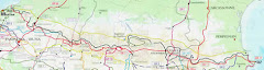
We have made it from the Atlantic coast to a small hill town in Navarra.
Our first day took us 20 miles from Cap de Higuer through Hondarribia (lovely small old Basque town with a a big stone castle, narrow streets with timber balconies brightly coloured and filled with geraniums, by sunbathers on the beach (VERY tempting), along a motorway in blazing sun and in to a town called Irun (not very attractive) and then out the other side in to the mountains. We made it to Vera de Bidasoa on the first night - arriving about 10pm VERY tired.
Day 2 took us from Vera to Elizondo. Another long day in the green hills winding around the valleys. There are numerous concrete bunkers dotted around the hills - Im not sure if these are from the Civil War or the Second World War.
I have never seen countryside with no flat bits. Even the Lake District has some valley bottoms but not Euskadi! It is either UP or DOWN - and very steep. However, it is a very beautiful place - very green, with beech woods, oak trees, ferns, lots of sheep, cows and farmhouses. We have had big showers in the afternoons but sunny mornings and evenings. Plenty of cloud cover too so it has been good for walking.
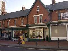
So now we are in Elizondo, a lovely hill town in Navarra. Here are some photos. We were going to press on today but it rained a lot last night a weather warning has been issued for today. The river in town is high and we decicded to give ourselves a day off to soothe our (very) sore limbs. It will be good to have time to look around town and see the sights. We had a good meal in a restaurant last night watching pelota on the tv. Pelota? It´s the Basque national sport. Bit like squash but with only a front and one side wall. And no racquet! Mmm...
Saturday 31 May 2008
Friday 30 May 2008
News from Elizondo

Hi!
I've some news about our friends. I've recived a SMS from Sara and they will call me tomorrow.
Now, they are in Elizondo as planned. They have been walking for 12 hours this lasts two days and are a bit tired and "scared". But they're ok. Tomorrow they've to walk a shorter distance.
Hola!
Tinc noticies dels nostres amics. He rebut un SMS de la Sara i demà em trucarà.
Ara estàn a Elizondo, tal i com tenien previst. Han estat caminant durant 12 hores aquests darrers dos dies i estàn un xic cansades i espantades. Però es troben bé. Demà la distancia serà més curta.
Tuesday 27 May 2008
Our schedule / El nostre itinerari


Photo of me at the start, me and Sara with flag of Euskadi and the hotel at Hondarribia
I´m afraid that it is a long itinerary, but we are away for 50 days so what do you expect? So feel free to skip this posting if you don´t suffer from insomnia...
Em sap greu que sigui un itinerari tan llarg, però estem fora 50 dies, doncs que espereu? Llavors podeu sentir-vos lliures d'escapar-vos d'aquest "posting" si no patiu de insomni ....
First night in Hondarribia Day 0, 28.05.08
Taxi from station to Hotel San Nicolás, Plaza armas 6, 943 64 42 78
E80. Taxi E6
29.05.08
Day 1: 32.5km, 5.30 h. Cabo de Higuera to Bera to Caseria Gorra to camp
Water: fountain 10km,
Night 1: camp, Gorra. 2.5km AFTER Bera
Provisions: Irun and Bera COOK
30.05.08
Day 2: 27.5km, 7.10h. Gorra to Elizondo
Water:, fountain at 24km (Maistruzar)
Night 2: Casa Eskisaroi, 948 580 013, 2 doubles, 25 + 12.50E
Provisions: shops and restaurants here
31.05.08
Day 3: 18km, 5.25h. Elizondo to Urkiaga
Water: Elizondo and fountain at 11km (Collado Zaldegi), fountain at final (rio arga)
Night 3: Camp by bunker…check uk book.
Provisions: ONLY IN ELIZONDO.
01.06.08
Day 4: 15km, 4.55h, Urkiaga to Burguete / Auritze
Water: BAR a 7km (Casa Pablo)
Night 4: zona camping Urrobi, 2 km south 948 76 02 00
Provisions: Breakfast and dinner at camp site
02.06.08
Day 5: 20km,, 5.10h. Burguete / Auritze to Orbaiceta / Orbaitztako
Water: 13km fountain collado bentartea, rivers and houses at end
Night 5: Booked Mendilatz, 948 766 088, E122 with dinner and breakfast OR ZONA CAMPING SEE UK BOOK
Provisions: Orbaitzeta
03.06.08
Day 6: 6km, 3.55h. Orbaitzeta to Casas de Iratí
Water: fountain at 6km, embalse
Night 6: Camping….off route.
Provisions: Nothing!
04.06.08
Day 7: 14km, 4.15h. Casas de Iratí to Ochagavia
Water: 13km Santuario, Ochagavia
Night 7: zona camping or hostal….check camping ochagavia 948 89 01 84, also hostal Oryalde 948 890 027
Provisions: shops etc in Ochagavia
05.06.08
Day 8: 23km, 5.40h. Ochagavia to Isaba
Water: NO
Night 8: zona camping or hostals Isaba: Asolaze, 94889 30 34. Oxanea, 948 89 31 53 , pension txiki 948 893 118 . no suitable camp area
Provisions: Isaba
06.06.08
Day 9: without peak: 13km, 3h, Isaba to Zuriza. WITH PEAK 6H, 15.6KM
Water: River all the way. For peak lake?
Night 9: Camping de Zuriza. 974 37 53 88 or Anso at 3km from Zuriza 974 37 01 12
Provisions: camping
07.06.08
Day 10: 11km, 5.30h, Zuriza to Guarrinza
Water: Streams?
Night 10: REFUGIOS NO GUARDADOS, camp wild at La Mina (see uk book)
Provisions: NONE
08.06.08
Day 11: 20km, 7.10h, Guarrinza to Cadanchu
Water: streams and lakes
Night 11: CADANCHU, el aguila, 974 37 32 91. Valle del aragon, 974 37 32 22 or refugio no guardado Selba d’Oza o campamento Ramiro el monje
Provisions: “ “ “ “
OR DAY 11: GR11.1 TO CANFRANC
09.06.08
Day 12: 18km, 7.55h, Oza to Refugio / Cubillar de Lizara. MAJOR ASCENSION
Water: Fountain at 7km and at 17km also refugio guardado at 8.5km
Night 12: Refugio Lizara 974 371 473
Provisions: Refugio at 8.5km and Refugio Lizara (¿)
10.06.08
Day 13: 15km, 7.30h, Lizara to Canfranc
Water: Fountain at 10.5km, streams
Night 13: Hostal Canfranc, C Mayor 19, 974 37 32 17 or camping 608 73 16 04, at station Pepito Grillo 974 373 123, La Cabana 372 119, El Rincón 372 137
Provisions: Canfranc, restaurants but no shop
STICKING TO GR11 ARRIVING AT CADANCHU
09.06.08
Day 12 (map14): Option 1: 22km, 7.45h. candanchu to sallent
Water: lakes and streams
Option 2: 15km, 5.25h
Water: streams
Night 12: TOWN SALLENT has campsite OR Refugio Respumoso 974 49 02 03 …walking further than map end MAYBE TOO MUCH? Albergue in Sallent – Foratata 974 488 112, Hotel El Centro 974 488 019
Provisions: Refugio and Sallent de Gallego, shops, bank etc
10.06.08
Day 13: (map 15) 20km, 10.35!!!!!!!!!! or less if leaving from Respumoso Sallent to Balneario de Panticosa
Water: refugio and lakes
Night 13: Refugio de Respumoso or 3 refugios no guardados or arrive at Balneario and refugio casa de piedra 974 487 571 VISIT BALNEARIO NEXT DAY? REST DAY?
Provisions: refugio
11.06.08
Day 14: (map 16) 18km, 9.05h. Balneario to San Nicolas de Bucaruelo
Water: lakes and rivers
Night 16: Bujarelo camping Torla 974 48 63 48 y 974 48 61 61
Provisions: Camping
12.06.08
Day 15: (map 17) 20km, 7.30h, Bujaruelo to Goriz
Water: 3 fountains after 10km, rivers
Night 17: Refugio de Goriz, 974 34 12 01
Provisions: Refugio
13.06.08
Day 16: (map 18) 11km, 10.30h, Goriz to Refugio Pineta, see options on map
Water: rivers
Night 18: Refugio de Pineta: 974 50 12 03
Provisions: Refugios
14.06.08
Day 17 : (map 19) 18km, 6.45h, Pineta to Parzan
Water: Fountain refugio no guardado at 6km, fountain at 10km
Night 17: Parzan: Casa Marion: 974 50 11 90, Hostal La Fuen (inc restaurant) 974 50 10 47
Provisions: Bielsa and parzan
15.06.08
Day 18: (map 20) 19km, 8h, Parzan to Biados
Water: Fountain at 16km, streams
Night 18: refugio biados 974 50 07 27 / 506 082 / 506 163
Provisions: refugio
16.06.08
Day 19: (map 21) : 20km, 8.30h, Biados to Puente de San Chaime
Water: fountains at 0.5km, 12km, 16km
Night 19: 2 campings: tels not listed or Hotel Benasque (3KM MORE)
CHECK NUMBERS
Provisions: campings, FOOD FOR DAY IN BIADOS, benasque
16.06.08
Day 19 : (map 21) 3 refuge circuit: Biados to forcau ALTA MONTANA
Biados to Forcau: 9.5km, 7.25h
Water: at 0.5km, lakes
Night 19: refuge Forcau angel orus 974 34 40 44
Provisions: refuges
17.06.08
Day 20: (map21) Forcau to Refuge d’estos, 10.5km, 7.15h
Water: lakes
Night 20: Refuge d’Estos 974 55 14 83
Provisions: refuges
18.06.08
Day 21: (map 21) 9km, 3h. Estos to San Chaime or benasque
Water: river, gorges
Night 21: camping or CHECK HOTEL BENASQUE. Refugio Llanos de Hospital 608 536 053, Refugio de la Renclusa 974 552 106
Provisions: Benasque. Eat in Benasque and return to San Chaime?
19.06.08
Day 22: (map 22) 22km, 10h, San Chaime to Refugio Llauset
Water: fountain at 7km, lakes
Night 22: REFUGIO LLAUSET no guradado
Provisions: what we bought in Estos or camping or Benasque
20.06.08
Day 23: (map 23). 10km, 4.30h. Refugio de Llauset / Aneto / Refugio de Llauset
Water: lakes
Night 23: Refugio Llauset
Provisions: Buy in Aneto and eat there!
21.06.08
Day 24: (map 23). 13km, 4.45h. Llauset to Espitau de Vielha
Water: lakes
Night 24: ESPITAU DE VIELHA near túnel: 973 69 70 52 / 619 977 264
Provisions: Aneto. Espitau…albergue?
22.06.08
Day 25: (map 24) 15.5km, 8.25 (MAJOR ASCENSION) or 21km, 8.05h. hospital de Vielha to REFUGI DE COLOMERS
Water: Fountain at 5km, lakes
Night 25: Refugo de Colomers 973 25 30 08 / 973 64 05 92 or stop in refuge de restanca 608 036 559
Provisions: refuges
23.06.08
Day 26: (map 25) 10km, 6.15h, Colomers to Refuge Sant Maurici
Water: lakes lakes lakes
Night 26: Refuge Ernest Mallafre 973 25 01 18. Option of stopping at Refuge d’Amitges 973 25 01 09 / 973 25 00 07
Provisions: refuges
24.06.08
Day 27: (map 26) 15km, 4.20h, Sant Maurici to Espot to La Guingueta
Water: lakes
Night 27: camping la guingueta 973 62 60 83
Provisions: pass through 3 towns and la guingueta
25.06.08
Day 28: (map 29). 9.5km, 5h, La Guingueta to Estaon
Water: fountain 1.5km and 8km
Night 28: albergue? Aterpe 973 62 32 87. Estaon snra rosa feliu – 973 623 031
Provisions: Estaon?
26.06.08
Day 29: (map 30) 11km, 4.20. Estaon to Tavascan ASCENT 600M
Water: Font dels Camps see map
Night 29: Tavascan. Hotel Marxant 973 623 151
Provisions: Tavascan
27.06.08
Day 30: (map 30) 16km, 6.30h, Tavascan to Areu
Water: fountain 4.5km
Night 30: Areu CHECK HOSTAL or camping, 973 62 90 47 (Pica d’estats)
Provisions: Tavascan and Areu
28.06.08
Day 31: (map 31) 15km, 5.05h, Areu to refugi de Baiau (no guardado but ok) or stop in refugio de vall ferrera
Water: Areu, refugio vall ferrera, lake at end
Night 31: refugio Baiau no guardado or vall ferrera
Provisions: stock up in areu or dinner in vall ferrera. COOK
29.06.08
Day 32: (map 32) 13km, 5.50h MAJOR UPS AND DOWNS, Baiau to Arans
Water: Lake at 2km and Refugi Coma Pedrosa 00 376 608 327 at 4 (food)
Night 32: Arans. Camping ansalonga 3km south
Provisions: Ansalonga campsite
30.06.08
Day 33: (map 32) 13km, 5.48h, Arans to Encamp
Water: Ordino
Night 33: Encamp. Camping valira 973 83 16 09. Hotel consol 00 376 831 035
Provisions: stop to eat in ordino? Encamp
01.07.08
Day 34: (map 33), 19km, 5.50h, Encamp to Cabana dels Esparvers
Water: Refuges?? River, lakes
Night 34: Cabana dels Esparvers. Small stone cabin, 2 to 3 people
Provisions: stock up in Encamp. COOK
02.07.08
Day 35: (MAP 35) , 9km, 4.05h, Esparvers to Refugi de Malniu
Water: river, lakes, refuges and fountain at end
Night 35: Refugi Malniu (Meranges) , 93 825 71 04, 616 855 535
Provisions: day food from encamp and dinner / picnic malniu
03.07.08
Day 36: (map 36), 14km, 3.40h, Malniu to Puigcerda (descent)
Water: fountain at 9km
Night 36: camping Stel, 972 88 23 61 or hostal terminus 972 880 002
Provisions: Puigcerda
04.07.08
Day 37: (map 37), 24km, 6.20h, Puigcerda to Planoles
Water: fountain at 19km
Night 37: Camping Can Fosses CHECK NUMBER. Alberg Pere Figuera 972 73 61 77, Corral Blanc 972 73 60 00
Provisions: Planoles
05.07.08
Day 38: (map 38), 14.5km, 5.50h. Planoles to Nuria
Water: fountain at 1km and in Queralbs. Refuge queralbs 936 824 237 / 198 082
Night 38: Santuario de Nuria, Alberg Pic d’Aliga 972 73 20 48 / 972 73 20 43
Provisions: Queralbs and Nuria
06.07.08
Day 39: (map 39), 19.5km, 6.10h. Nuria a Set Cases
Water: Refugi Ulldeter 12km 973 192 004 / 482 319
Night 39: Set Cases Can Tiranda 972 136 052
Provisions: Set Cases…and that restaurant
07.07.08
Day 40: (map 40), 20.5km, 6.08h, Set Cases to Beget
Water: Mollo town at 10km
Night 40: Beget CALL MONICA
Provisions: Beget and Mollo
08.07.08
Day 41: (map 41), 14.5km, 4.30, Beget to San Aniol d’Aguja
Water: fountain at 6km
Night 41: Camping NO CAMPSITE, NO NOTHING, field near church, refuge Can Galan
Provisions: NONE
09.07.08
Day 42: (map 42), 16km, 5.35h, San Aniol to Albanya
Water: fountain at 7km
Night 42: Albanya, camping bassegoda
Provisions: Albanya
10.07.08
Day 43: (map 43), 15.5km, 4.30h, Albanya to Macanet de Cabrenys. Or to Vajol 27km
Water: fountain at 9.5km and 14km
Night 43: camping area or Hostal La Cuadra 972 544 032
Provisions: Macanet
11.07.08
Day 44: (map 44), 27km, 9h, Macanet to Requesens
Water: fountain at 1.5km and La Jonquera 21km
Night 44: camp wild in Requesens Or camp site in La Jonquera (makes next day longer)
Provisions: Requesens has bar but no campsite
12.07.08
Day 45 (map 45), 27km. 6.25h Requesens to Vilamaniscle UK book goes to Sant Quirze where bar and restaurant but camp wild
Water: ELS VILARS CHECK 12km
Night 45: CHECK VILAMINISCLE
Provisions: CHECK VILAMANISCLE
13.07.08
Day 46: (map 46), 16km, 4.30h. Vlamaniscle to Port de la Selva
Water: Llanca 8km, fountain 13km sant pere de rodes
Night 46: Port de la Selva, Camp-site L’Arola 972 38 70 05
Provisions: No problem….the diet’s over
14.07.08
Day 47: (map 47), 13km, 4h, Port de la Selva to Cap de Creus
Water: NONE
Night 47: GET PICKED UP….night in Cadaques or home?
Hola from Catalunya!

I arrived in Girona yesterday and have been eating and drinking since I was collected from the airport by Sara and Sandy. All in the name of training for our endurance event of course.
We took the dogs for a walk for one hour through the fields around Vidreres this afternoon and we are tired already. It must be the wine that we had for our 2 hour lunch today.
Vaig arribar ahir a Girona i he estat menjant i bebent desde que la Sara i la Sandy van venir a recollir-me a l'aeroport. Tot per preparar la nostra aventura.
Hem anat amb els gossos a passejar durant una hora per els camps vora Vidreres aquesta tarda i ja estem cansats!!!! Deu ser per tot el vi que hem estat bebent en el menjar que ha durat dos hores.
Sunday 25 May 2008
Sunday evening. Last post from the UK!

Okay, so I am packed.
I can't find my earplugs.
I think that everything else is in the rucksack though. Hoping to get some bubblewrap in Spain to use as a groundsheet.
Time has gone so fast but departure is almost here. Did some cycling today along the Derwent Walk in the sun and should I tell you a secret? Well... Spring is being so fantastic here this year that it's a pity to be leaving the UK, but I'm sure the Pyrenees will be just as amazing. It's great to wonder what I will encounter in the next 50 or so days. I hope to share some great times with Sara and Sandy.
How to donate to St Oswald's Hospice
I have had several enquiries about donating to the Hospice. This is because:
1. Some people can't access the justgiving.com site from their computers
2. Some people don't like donating online
3. Some people would rather make a donation in person (which is a nice thought)
4. Some people will see me before and after the walk and can just hand the donation over
5. Probably other reasons that I don't know of yet
So if you would rather not donate online I have sponsorship forms that people can fill in with your details and your pledge, or post a cheque to me if you have my address. You can also make a pledge on the 'comments' at the foot of this blog entry.
If you don't have my address send me an email to bykercolin@yahoo.co.uk and I can give you details. It's best to wait until I am back in Newcastle in August before sending it to me.
I will collect the money (cash or cheque) from people who let me know that they want to sponsor me.
Does that cover everything? A big thank you to all who are sponsoring me. It makes me feel a lot better about walking so far!
Too late to panic now!
I've packed all my things. My rucksack weighs too much already...
so I will empty it and throw out half of it. How many pairs of socks do I really need?
so I will empty it and throw out half of it. How many pairs of socks do I really need?
Saturday 24 May 2008
Final preparations
Here is the latest on the weather from Sara in Catalunya:
"Have stopped panicking about snow as it is only over 2200m. Weather is mixed and not too hot. When we start it should be quite cool and it always rains in the Basque Country".
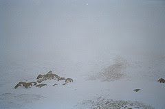
What happens when we go over 2200m? Get the snow shovel out.
Snow? This is a photo taken on Sticks Pass in the Lake District in January.
"Have stopped panicking about snow as it is only over 2200m. Weather is mixed and not too hot. When we start it should be quite cool and it always rains in the Basque Country".
What happens when we go over 2200m? Get the snow shovel out.
Snow? This is a photo taken on Sticks Pass in the Lake District in January.

Things to do No. 4: do some knitting
For those of you who are interested I have a knitting blog too, its named after a mountain in the Lake District - Nitting Haws - mainly because its a funny name but also because I love Herdwick sheep and their wool. The link is over on the panel to the right.
But I digress from the Pyrenees. In fact, as you may have seen from the article on BBC/Tyne, I am going to try and find some locally produced wool while I am up in the mountains. The economy of the towns and villages was based on wool, but now they are either deserted or rely on tourism. Tourism, tourism, tourism - but may be I am contributing to this dependency to. Do people actually MAKE things anymore, or do we just want everything imported cheaply. What made me mad the other week was finding some yarn in a shop that had been produced in China, finished in Australia and then found itself on a shelf in Newcastle. What's wrong with local wool? Rant (almost) over.
So will Pyrenean wool be available, or like in the UK do we just want standard synthetic stuff with no character?
Things to do No. 3: weed the allotment
As I will be away for 2 months I need to get down the allotment to do some weeding and watering. It will also help me to relax. And of course I can pop in to The Heaton Perk for a coffee, cake and do some knitting.

Things to do No. 2: get my hair cut
My mate Paul came round for dinner last night and fortunately he has a former life as a hairdresser - so before we ate he cut my hair!
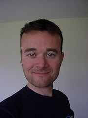
I am very impressed I must say. Subtle but Contemporary I think! Practical for the trek - no maintenance needed, short enough not to get hot but long enough to keep warm and keep the sun off my scalp. Cool. Waddya think?
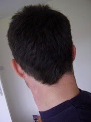
This is the back view, perhaps more attractive? Here I am talking about my hair. Do you think that I am in denial about getting ready to walk the Pyrenees. I should be packing...
Things to do No. 1: Pack my rucksack
Today I have started in earnest to see what I need to take. The strategy behind this is to leave it to the last minute which means I will take as little as possible. I guess that the maximum weight should be about 11kg. Once I meet up with Sara and Sandi I will be carrying some of the shared equipment too - cooking stuff, food, water, the inflatable swimming pool (that one was a joke).
So it is paring things back to the minimum I will need for 7 weeks in the mountains. What are the luxuries I can't do without?
1. dental floss
2. my watercolour set
3. of course my knitting needles and yarn
4. any other suggestions before I go?
So it is paring things back to the minimum I will need for 7 weeks in the mountains. What are the luxuries I can't do without?
1. dental floss
2. my watercolour set
3. of course my knitting needles and yarn
4. any other suggestions before I go?
Friday 23 May 2008
Some detailed information on what the walk entails
I have been requested to give some more details about what we are planning to do - so you did ask!
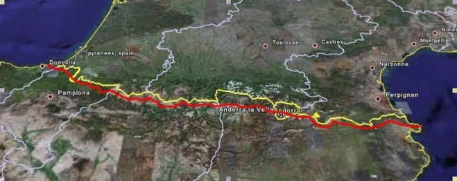
We will be walking West to East - from the Atlantic Ocean to the Mediterranean Sea.
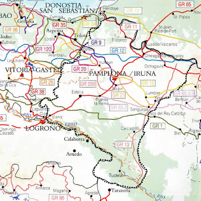
1. In Euskadi the route is short (about 30 km). We start at the lighthouse at Capo de Higuer and continue as follows: Cabo de Híger, Hondaribía, Irun and col of San Antón.
2.In Navarra the route is about 180 km long. We enter Navarra by the col of San Anton and Vera de Bidasoa, followed by the valley of Baztán, Elizondo, Roncesvalles, forests of Quinto Real, Sierra de Abudi (peak of Orhi), Orbaitza, Selva (forest) de Irati , Ochagavía, Isaba, peak of Ezcaurri (2,045 m) and Zuriza.
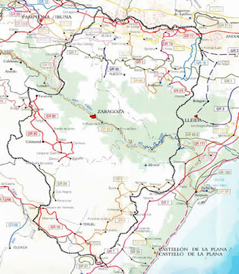
3.In Aragon (there is quite a lot to see and experience in the 200km of the route in Aragon) , the route is really mountain and requires a minimum of knowledge and experience in climbing.
From Navarra, the route goes to the refuge of La Mina (GR 11-1), Candanchú and the valley of Tena, by the Canal Roya or by the Canal Izas.
After the refuge of Respomuso and Panticosa, the route goes into the valley of El Ara and, after that, to the wonderful National Park of Ordesa and Monte Perdido.
After the col of Vallhiverna, the route goes down to Catalonia by the valley of Llauset and the village of Aneto, or by Angliós and the bridge of Salenques.
Route: Zuriza, refuge of Taxeras, col of Petraficha, refuge of La Mina, Aguas Tuertas, Port d'Escalé, Ivó de Estanés, Candanchú. By the Canal de Izas: Candanchú, picnic area of Canal Roya, dam of Izas, refuge of Iserías, col of Izas, Formigal. By the Canal Roya: picnic area of Canal Roya, refuge of Lacuas, Anayet, Formigal, Sallent de Gállego, La Sarra, Respomuso, col of Tebarray, col of El Infierno, dam under the river Bachimaña, health resort of Panticosa, upper dam of Brazato, col of Brazato, river Ara, refuge of Ordiso, San Nicolás de Bujaruelo, Pont dels Navarresos, parking of Ordesa, Cirque of Soaso, refuge of Góriz, col of Arrablo, Fuen Blanca, col of Añisclo, Cirque of Pineta, La Larri, col of Piedramula, river Real, Chisagüés, Parzán, C.E. de Urdiceto, Paso de los Caballos, Bordas de Lizier, Es Plans, refuge of Biadós, Añes Cruces, Pass of Chistau, refuge of Estós, Santa Ana, bridge of San Jaime, Plan de Senarta, refuge of El Puente de Coronas, col of Vallihiverna. Junction - by the valley of Salenques: small col of Riu Bueno, Angliós, bridge of Salenques. By Aneto: dam of Llauset, refuge of Llauset and Aneto. There are two variants, the GR 11-1 that goes from La Mina to Canfrán by the refuges of Gabardito and Lizara; and the GR 11-2, a track from the refuges of Biadós, Ángel Orús and Estós.
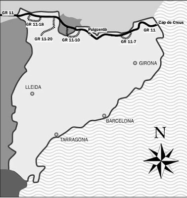
4. In Catalunya the GR11 has two sections with the Andorran section sandwiched between them. In total the Catalan section is 335 km long.
The first section has the following route: bridge of Salenques, hospital of Vielha (GR 211), pass of Rius, Tort lake, Rius lake, Mar lake, pass of Ratera Montardo, Sant Maurici lake, Espot, La Guingueta d'Àneu, Tavascan, Vall Ferrera, and pass of Baiau. From here on, the route goes into Andorra. It goes back to Catalunya by the pass of Vall Civera, with the following route: Esparvers cabbin (GR 107), Meranges lakes, Puigcerdà (GR 4), col of Toses, Planoles, Queralbs, Núria, col of La Marrana, Setcases, Molló, Beget, Bassegoda, Albanyà, la Vajol, la Jonquera, Sant Quirze de Colera, Llançà (GR 92), Sant Pere de Rodes and Cap de Creus.
It has the following variants: the GR 11-7: Núria, Camí dels Enginyers, refuge of Coma de Vaca, Coma de Freser and GR 11 near the col of La Marrana (this variant is 16 km long); GR 11-10: Les Escaldes, refuge of Perafita, refuge of Estanys de la Pera, refuge of Cap de Rec, Viliella and Esparvers cabbin (it is 31,154 km long); GR 11-18: refuge of Restanca, col of Güellicrestada, pass of Caldes and refuge of Colomers (it is 14,09 km long); GR 11-20: Pont de Suert, Durro, Boí, Taüll, pass of Rus, Tapat lake, col of Font Subirana, refuge of Colomina, col of Saburó, Negre lake, refuge of Josep M. Blanc and Espot (it is 27,400 km long); and the GR 11-20/1: refuge of Llauset, Aneto, Senet de Barravés, pass of la Gelada, Barruera and Boí.
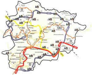
5. The Andorran section is about 40 km long and crosses the land from west to east. It enters by the Portella de Baiau (2,756 m) from the Vall Ferrera, and goes down by the Negre lake, the refuge of Comapedrosa, where it meets with the GRP1 and go on together until the beginning/end of the Andorran variant, the GR 11-8, where the GR 11 still goes down to Arinsal (1.600 m), from where it goes up again to the col of Les Cases (1,958 m). After it, it goes down again to Arans (1,300 m). After that, it goes up again to the peak of Sorovilles (1,740 m), descends to the Castle of Els Moros (1,450 m), up to the col of Ordino (1,983 m) and down to Encamp (1,250 m). From Encamp, the route goes up to the Engolasters lake (1,600 m) and goes on to Ràmio, where it meets the GR 7. Both routes go on together to Estall Serrer, where they meet the GRP1. The three routes go on by the same way until the refuge and lake of Illa (2,480 m), where the GR 11 separates from the other and still goes up to the pass of Vall Cibera (2,517 m), from where it goes down to the Esparvers cabin, in Catalunya.
We will be walking West to East - from the Atlantic Ocean to the Mediterranean Sea.
1. In Euskadi the route is short (about 30 km). We start at the lighthouse at Capo de Higuer and continue as follows: Cabo de Híger, Hondaribía, Irun and col of San Antón.
2.In Navarra the route is about 180 km long. We enter Navarra by the col of San Anton and Vera de Bidasoa, followed by the valley of Baztán, Elizondo, Roncesvalles, forests of Quinto Real, Sierra de Abudi (peak of Orhi), Orbaitza, Selva (forest) de Irati , Ochagavía, Isaba, peak of Ezcaurri (2,045 m) and Zuriza.

3.In Aragon (there is quite a lot to see and experience in the 200km of the route in Aragon) , the route is really mountain and requires a minimum of knowledge and experience in climbing.
From Navarra, the route goes to the refuge of La Mina (GR 11-1), Candanchú and the valley of Tena, by the Canal Roya or by the Canal Izas.
After the refuge of Respomuso and Panticosa, the route goes into the valley of El Ara and, after that, to the wonderful National Park of Ordesa and Monte Perdido.
After the col of Vallhiverna, the route goes down to Catalonia by the valley of Llauset and the village of Aneto, or by Angliós and the bridge of Salenques.
Route: Zuriza, refuge of Taxeras, col of Petraficha, refuge of La Mina, Aguas Tuertas, Port d'Escalé, Ivó de Estanés, Candanchú. By the Canal de Izas: Candanchú, picnic area of Canal Roya, dam of Izas, refuge of Iserías, col of Izas, Formigal. By the Canal Roya: picnic area of Canal Roya, refuge of Lacuas, Anayet, Formigal, Sallent de Gállego, La Sarra, Respomuso, col of Tebarray, col of El Infierno, dam under the river Bachimaña, health resort of Panticosa, upper dam of Brazato, col of Brazato, river Ara, refuge of Ordiso, San Nicolás de Bujaruelo, Pont dels Navarresos, parking of Ordesa, Cirque of Soaso, refuge of Góriz, col of Arrablo, Fuen Blanca, col of Añisclo, Cirque of Pineta, La Larri, col of Piedramula, river Real, Chisagüés, Parzán, C.E. de Urdiceto, Paso de los Caballos, Bordas de Lizier, Es Plans, refuge of Biadós, Añes Cruces, Pass of Chistau, refuge of Estós, Santa Ana, bridge of San Jaime, Plan de Senarta, refuge of El Puente de Coronas, col of Vallihiverna. Junction - by the valley of Salenques: small col of Riu Bueno, Angliós, bridge of Salenques. By Aneto: dam of Llauset, refuge of Llauset and Aneto. There are two variants, the GR 11-1 that goes from La Mina to Canfrán by the refuges of Gabardito and Lizara; and the GR 11-2, a track from the refuges of Biadós, Ángel Orús and Estós.

4. In Catalunya the GR11 has two sections with the Andorran section sandwiched between them. In total the Catalan section is 335 km long.
The first section has the following route: bridge of Salenques, hospital of Vielha (GR 211), pass of Rius, Tort lake, Rius lake, Mar lake, pass of Ratera Montardo, Sant Maurici lake, Espot, La Guingueta d'Àneu, Tavascan, Vall Ferrera, and pass of Baiau. From here on, the route goes into Andorra. It goes back to Catalunya by the pass of Vall Civera, with the following route: Esparvers cabbin (GR 107), Meranges lakes, Puigcerdà (GR 4), col of Toses, Planoles, Queralbs, Núria, col of La Marrana, Setcases, Molló, Beget, Bassegoda, Albanyà, la Vajol, la Jonquera, Sant Quirze de Colera, Llançà (GR 92), Sant Pere de Rodes and Cap de Creus.
It has the following variants: the GR 11-7: Núria, Camí dels Enginyers, refuge of Coma de Vaca, Coma de Freser and GR 11 near the col of La Marrana (this variant is 16 km long); GR 11-10: Les Escaldes, refuge of Perafita, refuge of Estanys de la Pera, refuge of Cap de Rec, Viliella and Esparvers cabbin (it is 31,154 km long); GR 11-18: refuge of Restanca, col of Güellicrestada, pass of Caldes and refuge of Colomers (it is 14,09 km long); GR 11-20: Pont de Suert, Durro, Boí, Taüll, pass of Rus, Tapat lake, col of Font Subirana, refuge of Colomina, col of Saburó, Negre lake, refuge of Josep M. Blanc and Espot (it is 27,400 km long); and the GR 11-20/1: refuge of Llauset, Aneto, Senet de Barravés, pass of la Gelada, Barruera and Boí.

5. The Andorran section is about 40 km long and crosses the land from west to east. It enters by the Portella de Baiau (2,756 m) from the Vall Ferrera, and goes down by the Negre lake, the refuge of Comapedrosa, where it meets with the GRP1 and go on together until the beginning/end of the Andorran variant, the GR 11-8, where the GR 11 still goes down to Arinsal (1.600 m), from where it goes up again to the col of Les Cases (1,958 m). After it, it goes down again to Arans (1,300 m). After that, it goes up again to the peak of Sorovilles (1,740 m), descends to the Castle of Els Moros (1,450 m), up to the col of Ordino (1,983 m) and down to Encamp (1,250 m). From Encamp, the route goes up to the Engolasters lake (1,600 m) and goes on to Ràmio, where it meets the GR 7. Both routes go on together to Estall Serrer, where they meet the GRP1. The three routes go on by the same way until the refuge and lake of Illa (2,480 m), where the GR 11 separates from the other and still goes up to the pass of Vall Cibera (2,517 m), from where it goes down to the Esparvers cabin, in Catalunya.

Some publicity for St Oswald's Hospice
The story of our epic adventure is going on the BBC/Tyne website to give me some publicity in my fundraising endeavours. If you would like to get some background information on me click on the BBC link on the right.
Wednesday 21 May 2008
More facts about the Pyrenees

I was right in thinking that the Pyrenees are 500km long - but that is as the crow flies! To walk the GR11 is 837km!
Then someone mentioned that the total ascent of 39,500m is in fact 4.5 times the height of Everest...
BUT I have arranged my insurance through the BMC (British Mountaineering Club) and have the Reciprical Card which will give me discounts in the refugios and campsites along the route and the rest of the time will be wild camping which is the bit I am looking forward to. Waking up in the mountains and cooking breakfast. In fact Sara and Sandi are much better morning people than me so I hope breakfast may be ready - oh, the smell of bacon and beans in the morning...
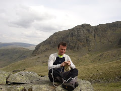
Talking of wild camping - the photo is me on High Pike in the Lakes last summer. It was pure bliss.
Tuesday 20 May 2008
... and here is the list!

Packing:
sleeping bag
tent
rain trousers
dry trousers and or shorts
leggings
thermal leggings
fleece
goretex
sun hat
rain hat
gloves
3 pairs socks
flip flops
trainers
first aid stuff (we have it)
sun cream
maps and book
ear plugs for snoring in refuges
3 t shirts and one thermal shirt
the eating and cooking things you might have or we get them here
insurance and federation card
camera
toiletries
The photo is of my belongings during my two week trek around the Lake District last summer. How do I fit in the tent?
can´t think of anything else
we have water bottles for you and have bought purifier
over-excited and indeed panicking.
Sunday 18 May 2008
Here's the other members of the Team...

Sandy and Sara. This is taken on Almouth beach when they came over to Newcastle from Spain for the Easter Weekend 2007. Bit of a bracing North Sea breeze, but they are a hardy couple! Which is good because I have a feeling that they will be looking after me quite a bit of the way!
Saturday 17 May 2008
The Preparation so far...
Erm, I've found my walking boots and compass. I can't find my silk sheet sleeping bag ANYWHERE. What else do I need?
1. sun cream
2. underpants
3. t-shirt x 3
4. trousers x 2
5. waterproofs
6. thermals
7. camera
8. toothbrush
9. soap
10. maps. I think Sara will bring these along.
What else?
Oh.
11. tent
12. sleeping bag
13. cup, plate, knife, fork and spoon
14. water bottle
15. sun/rain/snow hat
1. sun cream
2. underpants
3. t-shirt x 3
4. trousers x 2
5. waterproofs
6. thermals
7. camera
8. toothbrush
9. soap
10. maps. I think Sara will bring these along.
What else?
Oh.
11. tent
12. sleeping bag
13. cup, plate, knife, fork and spoon
14. water bottle
15. sun/rain/snow hat
Thursday 15 May 2008
What a CRAZY idea!

Talking with Sara and Sandi over the summer (probably with a bottle or two of Rioja involved) we decided it would be a good idea to walk the Pyrenees.
Except I didn't realise that they are 800km long. I thought that they were about 500km, which is quite enough! So approximately 500miles peaking at Pico de Aneto at 3404m.
AND then I read that it involves climbing a total of 39,500meters! I think that is the equivalent of 40 times the height of Helvellyn from sea level...and here is a photo of Helvellyn to give me some idea of what we are doing.
Subscribe to:
Posts (Atom)